Reference Year: 2024 • Source: U.S. Census Bureau • Last Checked: October 2026 • Submit Correction
Juab County, Utah
Authoritative civic guide, municipal directory, geographic facts, and information checked business resources across Juab County.
Executive Geographic & Civic Profile
Nephi
13,417
3,392 sq mi
4,500 – 11,877 ft (Mount Nebo, Wasatch Range)
1852
West Desert & Central Utah
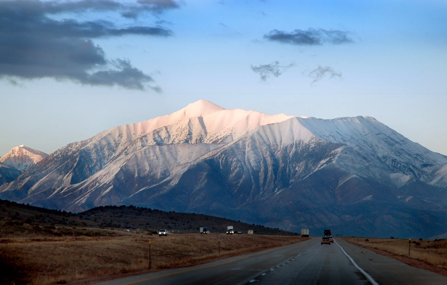
Geographic Boundaries: Bounded by Tooele and Utah Counties (Tintic Mountains, Mount Nebo crest) to the north, Millard County (Sevier Desert, Canyon Mountains) to the south, Sanpete County (Gunnison Basin, San Pitch Mountains) to the east, and White Pine County, Nevada (Deep Creek Mountains, Snake Valley) to the west. Extends from the crest of Mount Nebo—the towering highest summit of the entire Wasatch Range at 11,877 feet—westward through the agricultural and manufacturing corridor of the Juab Valley along Interstate 15, across the historic Tintic mining district, and across the vast West Desert rangelands to the isolated Deep Creek Mountains on the Nevada border.
According to official census demographic data (2024 U.S. Census Bureau Estimate), Juab County supports an established resident population of 13,417. Regional planning prioritizes balanced commercial growth, open-space preservation, natural resource stewardship, and active civic infrastructure.
Sovereign Tribal Lands & Jurisdictional Boundaries
In accordance with federal Indian law and sovereign jurisdictional boundaries, tribal reservations located within geographic county perimeters operate under independent tribal authority. San Juan and Juab County governments maintain no administrative, municipal, or licensing jurisdiction over sovereign tribal entities or reservation lands.
The far western edge of Juab County in the Deep Creek Valley is home to the sovereign Confederated Tribes of the Goshute Reservation (Ibapah / Deep Creek area), straddling the Utah-Nevada border. Goshute tribal lands operate under sovereign tribal council governance, with independent cultural resources and tribal regulations. Respect private tribal lands, livestock grazing boundaries, and sacred sites; visitors must remain on public thoroughfares and obtain authorized tribal permission for reservation exploration.
Geography, Elevation & Regional Climate
Juab County encompasses diverse Western topography ranging across elevations of 4,500 – 11,877 ft (Mount Nebo, Wasatch Range). The regional climate is characteristically semi-arid with four distinct seasons, featuring low relative humidity, abundant sunshine, and cold winters with snow accumulations concentrated across mountain watersheds and high plateaus. Annual precipitation supports native desert shrublands, pinyon-juniper woodlands, sagebrush steppe, and subalpine forests that define the regional geography.
Information Checked Directory in Juab County
Information Checked Directory & Public Services
Featured commercial enterprises physically operating in Juab County across core economic sectors, providing checked local services.
Central Valley Medical Center
Healthcare & Wellness
25-bed critical access community hospital in Nephi featuring a 24/7 Level 4 trauma emergency department, advanced orthopedic surgical suites, women’s health center, radiology, and outpatient specialty clinics.
Central Bank – Nephi Branch
Financial Services
Utah community bank branch on Main Street in Nephi offering agricultural operating loans, commercial equipment financing, personal checking, and mortgage lending in Juab County.
Mid-State Consultants
Professional Services
Professional engineering, broadband design, and consulting firm headquartered in Nephi, providing telecommunications architecture, fiber-optic engineering, and rural utility management nationwide.
Young Living Whispering Springs Farm
Recreation & Outfitting
Working commercial botanical farm and visitor center in Mona featuring expansive lavender fields, essential oil steam distillation tours, equestrian arenas, and family recreation grounds.
Search Juab County Business Directory
Direct access to local contractors, medical clinics, retail establishments, and professional services across Juab County.
Municipalities & Communities in Juab County
Explore incorporated municipal governments, civic centers, and regional hubs within Juab County.
Authentic Landscapes & Historic Architecture
Verified documentary photography showcasing public conservation areas, historic facilities, and scenic viewpoints in Juab County.
Resident Information & Municipal Services
Verified public administration, emergency management, school districts, and essential public utilities serving Juab County residents.
County Administration
- Juab County Commission (Three elected commissioners)
- Juab County Assessor’s Office (Property appraisal and tax assessment)
- Juab County Clerk / Auditor (Elections, corporate licensing, county budget)
- Juab County Recorder’s Office (Deeds, land surveys, historic mining claims)
- Juab County Treasurer (Tax billing and collections)
- Juab County Attorney’s Office (Criminal prosecution and civil representation)
- Juab County Building, Planning & Zoning Department
- Central Utah Public Health Department (Nephi Clinic Branch)
Public Safety & Emergency
- Juab County Sheriff’s Office (Patrol, 120-bed jail facility, 911 dispatch, West Desert search and rescue)
- Nephi City Police Department (Municipal law enforcement and traffic safety)
- Nephi Volunteer Fire Department (Structural firefighting, rescue, hazmat)
- Mona Volunteer Fire Department
- Levan Volunteer Fire Department
- Eureka Volunteer Fire Department
- Utah Highway Patrol (Section 7 patrol along I-15 and US-6 corridors)
Healthcare Resources
- Central Valley Medical Center (Nephi – CVMC is a 25-bed critical access hospital, 24/7 Level 4 Trauma Emergency Department, surgical services, orthopedic clinic, women’s health, radiology, rehabilitation)
- Central Valley Clinic in Nephi (Comprehensive outpatient primary care and pediatrics)
- Eureka Medical Clinic (Rural community clinic outreach)
Education & Libraries
- Juab School District (Juab High School in Nephi, Juab Junior High, Mona Elementary, Red Hills Elementary; approx. 2,800 students)
- Tintic School District (Tintic High School in Eureka, Eureka Elementary, West Desert High School in Trout Creek; serving western county communities)
- Snow College & Utah Valley University Distance Learning Centers (Concurrent enrollment and technical courses in Nephi)
- Nephi Public Library (Downtown municipal library, high-speed public computing, community book clubs)
- Eureka Public Library (Historic Tintic mining collection and community lending library)
Transportation Arterials & Public Transit
- Interstate 15 (Major national interstate corridor running north-south through Nephi and Mona)
- U.S. Highway 6 (National highway connecting Spanish Fork through Eureka and the Tintic Mountains toward Delta)
- Utah State Route 28 (Connecting Levan south along the Sevier River toward Gunnison)
- Utah State Route 132 (Connecting Nephi west to Lynndyl and east through Salt Creek Canyon to Fountain Green and Sanpete Valley)
- Pony Express Trail National Back Country Byway (Historical unpaved route crossing the vast West Desert through Callao)
- Nephi Municipal Airport (U14 – General aviation, 4,300-ft paved runway, parachute jumping, air ambulance)
- Salt Lake Express (Intercity scheduled coach connections north to Provo/Salt Lake and south along I-15)
- Juab County Senior Citizen Van Services
Parks, Public Lands & Outdoor Recreation
Federal conservation lands, state parks, and regional recreation areas throughout Juab County.
Federal Public Lands (NPS, BLM, USFS)
- Uinta-Wasatch-Cache National Forest – Spanish Fork Ranger District (USFS – Mount Nebo Wilderness, Devlis Kitchen geological formation, Salt Creek Canyon)
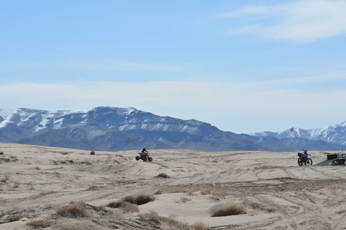
- Little Sahara Recreation Area (BLM – 60,000-acre extensive sand dune playground with Sand Mountain, White Sands, and 4WD riding)
- Fishlake National Forest – Fillmore Ranger District (USFS – Canyon Mountains in southern Juab County)
- BLM Fillmore & West Desert Field Offices (Deep Creek Mountains, Tintic Mining District, Pony Express trail corridors)
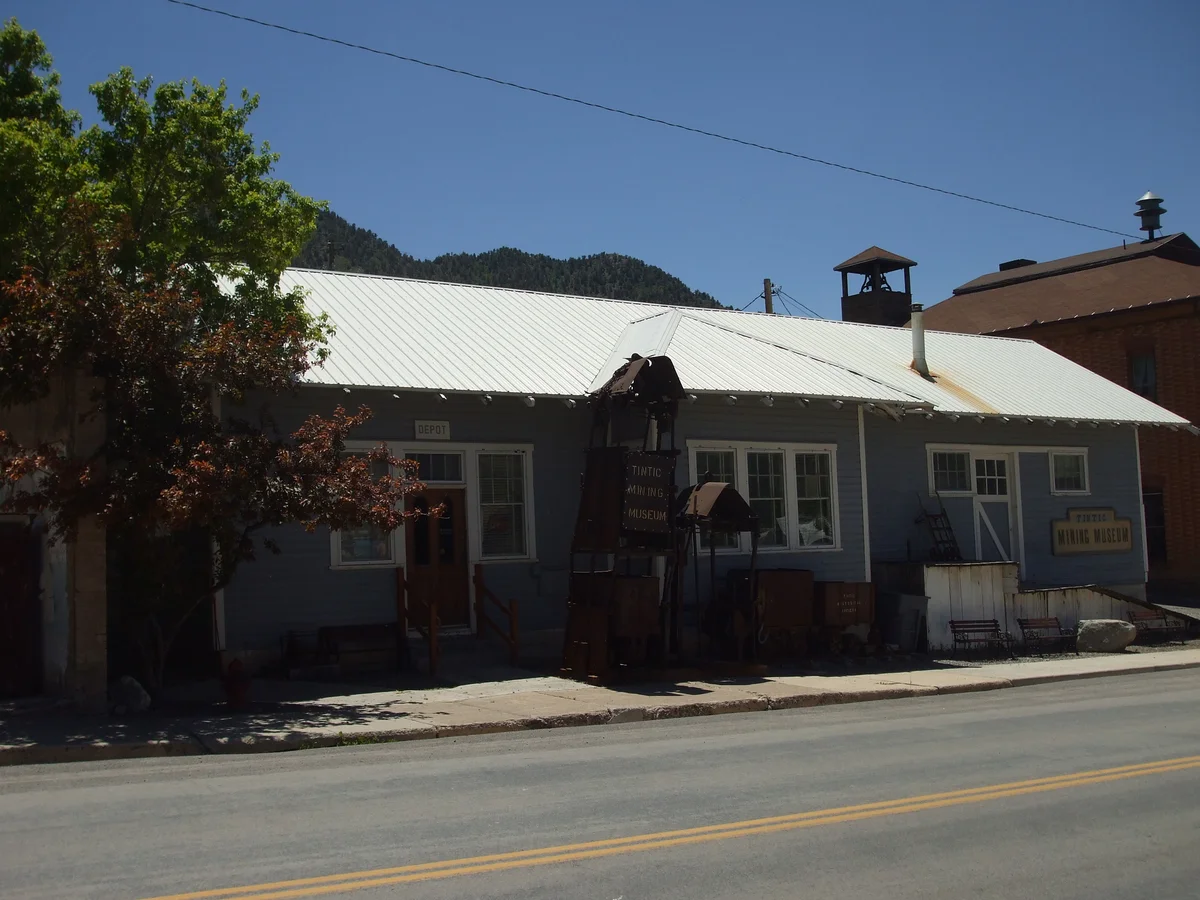
- Tintic Historic Mining District in Eureka (National Register historic district with preserved late-19th-century headframes, stone architecture, and museums)
State Parks & Regional Attractions
- Yuba State Park (Juab/Sanpete county line – Yuba Reservoir warm-water boating, watersports, sandy beaches, camping)
- Nebo Loop National Scenic Byway (USFS – 38-mile scenic drive over the alpine ridges of Mount Nebo)
- Nephi City Parks and Canyon View Park (Baseball complexes, swimming pool, pavilions)
- Mount Nebo Summit & Trails (11,877-foot peak offering challenging alpine mountaineering with panoramic views across central Utah)
- Devil’s Kitchen Geological Area on Nebo Loop (Miniature natural red rock amphitheater often called a mini-Bryce Canyon)
- Young Living Lavender Farm in Mona (Expansive agricultural visitor farm with fragrant lavender fields, distillery tours, and events)
- Tintic Mining Museum in Eureka (Authentic historic artifacts, ore cars, mining machinery, and pioneer records)
Economic Landscape, Industry Sectors & Commercial Permitting
Juab County maintains an established economic base founded upon diverse commercial, agricultural, and industrial pillars. Commercial development operates under coordinated municipal-county guidelines: businesses within incorporated municipalities obtain commercial business licenses through their municipal clerk, while enterprises in unincorporated county areas are permitted directly through the Juab County administrative offices.
- Agriculture & Livestock (Irrigated grain, alfalfa, beef cattle, dairy farms, Young Living agricultural operations)
- Healthcare & Regional Medical Services (Central Valley Medical Center, clinical healthcare)
- Advanced Manufacturing & Industrial Materials (Plastics molding, metal fabrication, rubber manufacturing in Nephi)
- Transportation & Interstate Logistics (I-15 commercial trucking corridors, warehousing)
- Mining & Mineral Processing (Historic silver-lead mining, limestone quarrying, industrial aggregates)
All legal commercial entities operating in Utah must register their organizational charter with the Utah Division of Corporations and Commercial Code and maintain appropriate sales tax accounts with the Utah State Tax Commission. Consumers are encouraged to verify professional contractor, medical, and trade licensing directly through the Utah Division of Professional Licensing (dopl.utah.gov).
Annual Civic Events & Cultural Traditions
Signature annual festivals, county fairs, rodeos, and community celebrations held across Juab County.
- Ute Stampede PRCA Rodeo (Mid-July celebration in Nephi running continuously since 1934, featuring top PRCA rodeo champions, parades, and carnival)
- Juab County Fair (August agricultural fair, demolition derby, concerts, and livestock auctions at Nephi fairgrounds)
- Mona 24th of July Celebration (Pioneer Day parade, park festivals, and community fireworks over Mona Reservoir)
- Eureka Silver Jubilee (Celebration of historic mining heritage in the Tintic Mountains)
- Levan Pioneer Day Town Celebration
Regional Guides & Utah Travel Resources
Deepen your exploration of Juab County with regional itineraries, moving guides, and scenic driving routes.
Explore community profiles, civic directories, and local business ecosystems across Utah.
Statewide travel itineraries, public lands access, national monuments, and regional highways.
How local businesses can claim profiles and establish claimed profile status on Greater Utah.
Adjacent Counties & Regional Travel
Explore neighboring counties connected across Utah:
Promote Your Juab County Enterprise
Connect with residents, commercial buyers, and traveling visitors actively seeking trusted local services and products in Juab County.
📷 Image Provenance & Photography Attribution
✓ Real Location Verified
GreaterUtah strictly enforces an Image Authenticity & Media Provenance Policy. All documentary imagery depicts authentic Utah locations and is verified via staff photography, federal public-domain repositories, or verified Creative Commons records. AI-generated, synthetic, and deceptive imagery are strictly prohibited.
Mount Nebo summit ridge (11,877 ft) towering over the Juab Valley • Photo: Moondigger • License: CC BY-SA 3.0
Editorial Methodology: All facts in this guide are independently corroborated through official public records, municipal licensing files, state agency datasets, and federal land management records. Demographics reflect 2024 U.S. Census Bureau Estimate (Reference Year: 2024; Source: U.S. Census Bureau; Last Checked: October 2026).
Data Citations: State of Utah (Utah.gov), U.S. Census Bureau, Utah Division of Corporations, National Park Service, Bureau of Land Management, U.S. Forest Service, and Juab County administrative records.